
If you are looking for the best hikes to do in the Dolomites, you are in the right place. The Dolomites mountain range offers clear lakes, bold peaks, and quiet valleys that make every trail feel special. Whether you love long, challenging routes or gentle walks with great views, the Dolomites give you many choices that fit your style.
In this blog, I share 17 hikes that show the beauty of this region. I picked trails that offer great scenery, safe paths, and a real sense of adventure. Grab your boots, pack your camera, and get ready to discover some of the most beautiful places in the Dolomites.
TABLE OF CONTENTS
TIPS AND RECOMMENDATIONS FOR HIKING IN THE DOLOMITES
Here are some essential tips and recommendations for hiking in the Dolomites.
- Wear sturdy hiking shoes. Many of the trails in the Dolomites are rocky and uneven. Yes, also the famous and popular ones. Hiking shoes with a good grip can make your walks easier.
- Arrive early at the hiking trails. The Dolomites are a really popular destination (especially during the summer months) so arriving early is essential. Not only will you be able to enjoy the hike better but it is also mandatory if you want to find a parking spot. I am not joking with this one, for some trails, we arrived at 8:30 and we struggled to find a parking spot.
- Bring a small first aid kit in your backpack. I have to admit I tripped and fell twice during my Dolomites trip. Fortunately, I didn’t get very bad injured but I did get some small wounds so I was happy to be able to disinfect them immediately.
- Make sure you have travel insurance. Even though this doesn’t usually happen, it is always possible to get injured while hiking. As I just mentioned, I fell twice during my hikes and even though I was really fortunate to not get badly injured, one of my falls was quite messy. For a few seconds, I thought I had broken a finger but luckily it was just a sprain.
- Always bring a windproof and waterproof jacket with you (even during the summer months). The weather at the mountains can change really quickly, so it is good to be prepared.
- Most of the trails are well marked but it is always good to download the trail GPX map so that you don’t get lost. I always use the AllTrails App to get my trail maps.
- Hiking poles are not mandatory but they can be quite useful. I always bring them with me to have some extra support for my knees.
- Pack a head lamp. If you’re planning on doing a sunrise or sunset hike, you need to be prepared. A head lamp will help you stay on the trail in the dark.
- Follow the Leave No Trace Principles and keep the trails and nature clean.
THE 17 BEST HIKES IN THE DOLOMITES
The Dolomites are a hiking paradise and every nature and mountain passionate should visit them at least once in their life. There are so many hiking trails and possibilities to choose from, and all of them will reward your with amazing views.
Unfortunately, it is not possible to hike them all, so I have compiled a list with the best and most iconic ones, especially if this is your first trip to the Dolomites. All these hikes can be done in one day and don’t require any special equipment (apart from hiking shoes).
For each hike, I will share the distance, altitude gain, difficulty, trailhead, time needed and all the best recommendations to make sure you have the best possible experience! So let’s not wait anymore and start with the list of the best hikes in the Dolomites.
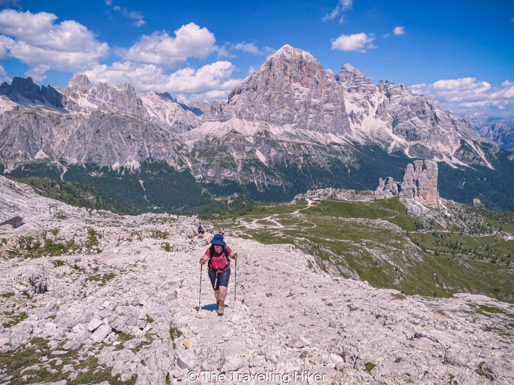
1. TRE CIME DI LAVAREDO
DISTANCE: 11,3 km
ALTITUDE GAIN: 597 m
LEVEL: Moderate
ROUTE TYPE: Circular
PARKING: Since June 2025, you have to reserve in advance your parking spot via the Auronzo Info Website.
TRAILHEAD/END: The trail begins at the parking lot next to Refugio Auronzo. The road to access it, is only open between June and September.
BEST TIME TO DO THE HIKE: Between June and August to increase your chances of good weather. It is not possible to access this hike by car during the winter.
ESTIMATED TIME NEEDED: 4 to 5 hours (depending on your fitness level and how many times you stop to enjoy the views)
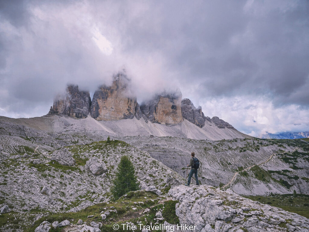
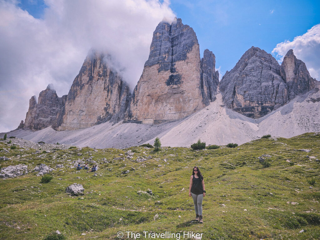
The Tre Cime di Lavaredo Loop is the most famous trail in the Dolomites, and it is easy to see why. The three sharp peaks rise high above the lanscape and create views that you will remember for a long time. The loop trail around the peaks is easy, well marked and offers breathtaking scenery from the very first steps (unless you are unlucky and do the hike on a cloudy day like we did). If you want to make this hike a bit more special, you can add some short detours to your route and include the Piani Lakes and some caves used during the World War.
The trail begins at Rifugio Auronzo and circuits around the peaks. It is not very hard, there are only two steep uphills but they are not that long. You will walk past rocky cliffs, green meadows, and mountain huts where you can rest and enjoy a simple meal or drink.
The best part of the hikes comes when you reach the area around Rifugio Locatelli. From here, the three peaks stand right in front of you, and the shape of the mountains feels almost unreal. Take your time at this spot. It is one of the most iconic views of the Dolomites.
Since 2025, you have to reserve your parking spot in advance if you want to reach the trailhead by car. However, it is also possible to access the trail by bus. If you have reserved your parking spot, you will not have any issues finding a parking spot but it is still recommended to start your hike early to enjoy it without too many people around you.
READ MORE: Tre Cime di Lavaredo Hike – Complete Guide
2. CADINI DI MISURINA
DISTANCE: 3,4 km
ALTITUDE GAIN: 211 m
LEVEL: Easy to Moderate
ROUTE TYPE: Out & Back
PARKING: Since June 2025, you have to reserve in advance your parking spot via the Auronzo Info Website.
TRAILHEAD/END: The trail begins at the parking lot next to Refugio Auronzo. The road to access it, is only open between June and September.
BEST TIME TO DO THE HIKE: Between June and August to increase your chances of good weather. It is not possible to access this hike by car during the winter.
ESTIMATED TIME NEEDED: 1,5 hours (depending on your fitness level and how many times you stop to enjoy the views)
The Cadini di Misurina is another very scenic trail in the Dolomites. The jagged peaks rise in sharp lines, and the view feels wild and dramatic. Most hikers do this hike just for the famous viewpoint, but the entire trail offers beautiful sights.
The trail begins near Rifugio Auronzo, so most people do it right before or after the Tre Cime di Lavaredo Hike. The path is mostly easy to follow with some uphills here and there. It does have some narrow and exposed parts, but they mostly stay manageable.
When you reach the famous viewpoint, the reward is incredible. The peaks rise in sharp towers before you in a stunning panoramic view. Just be prepared to wait in line if you want the famous Instagram spot.
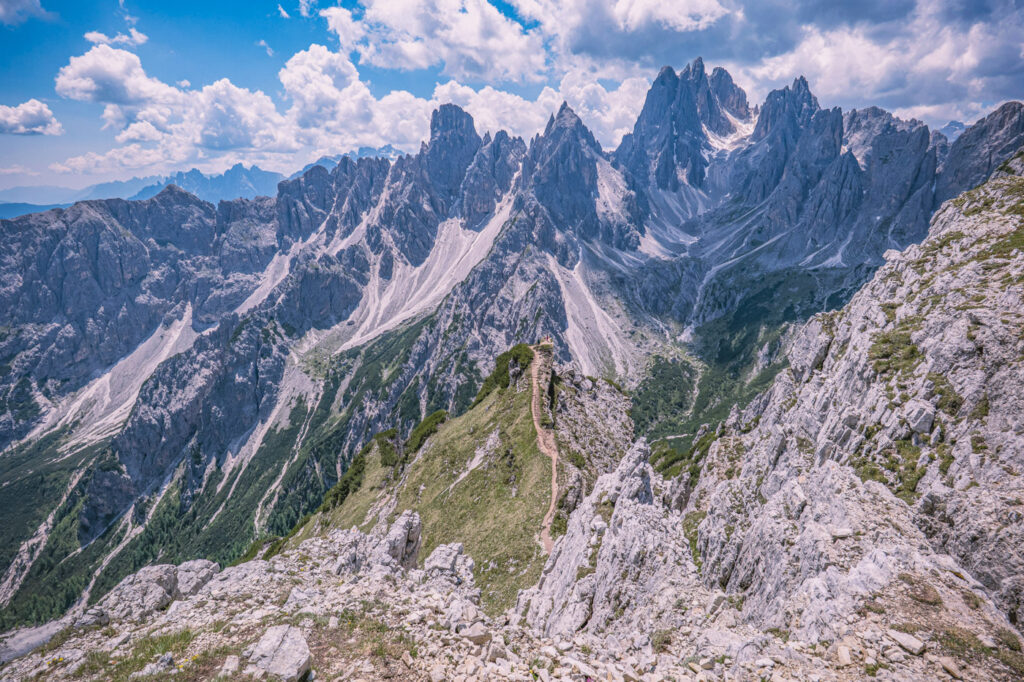
Photo by Marek Levák on Unsplash
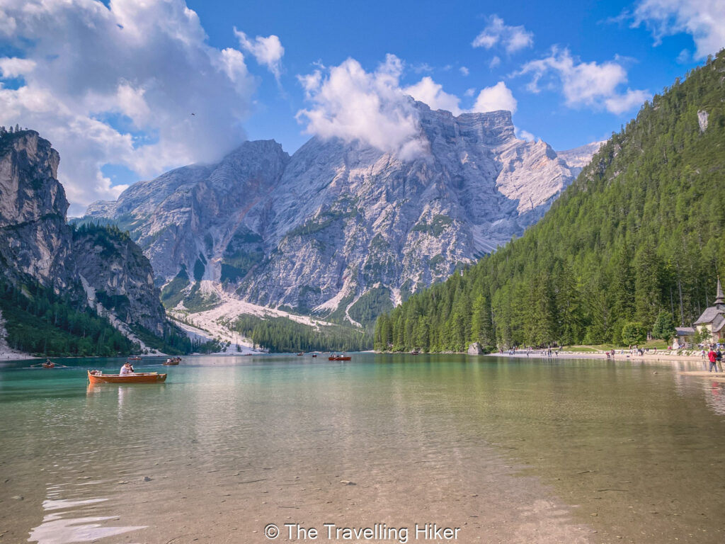
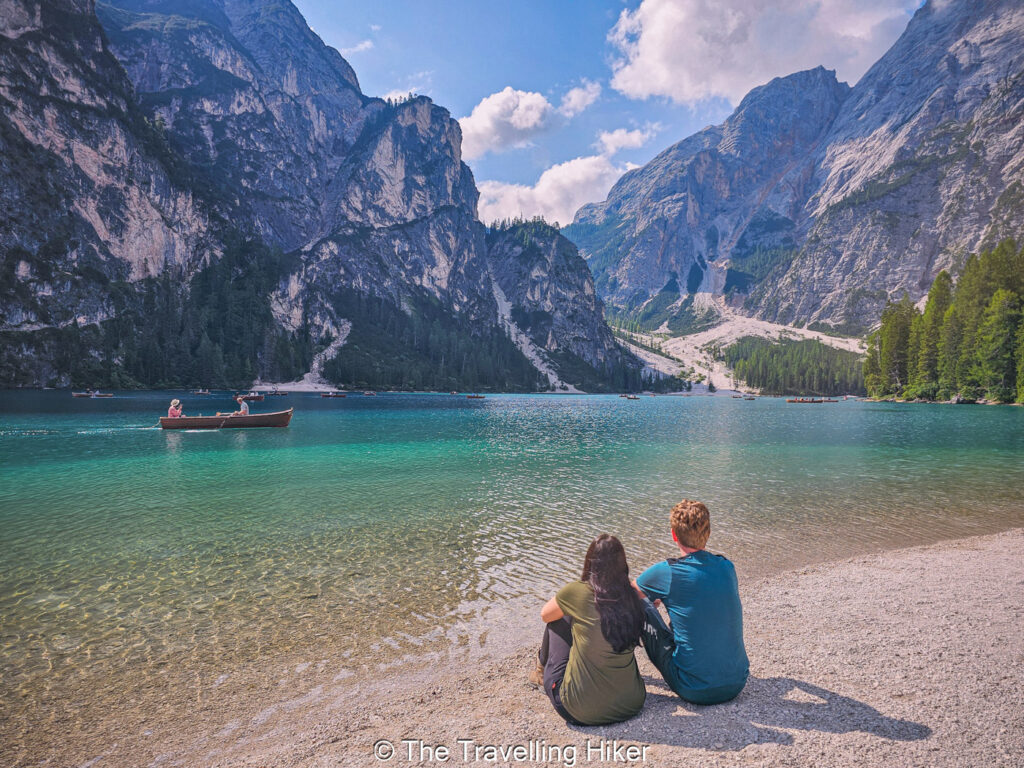
3. LAGO DI BRAIES
DISTANCE: 3,7 km
ALTITUDE GAIN: 189 m
LEVEL: Easy
ROUTE TYPE: Circular
PARKING: Since June 2025, you have to reserve in advance your parking spot via the Pragzer website.
TRAILHEAD/END: The trail begins next to the Hotel Lago di Braies.
BEST TIME TO DO THE HIKE: This hike can be done all year round. Depending on the season, you will be able to enjoy a very different panorama of the lake.
ESTIMATED TIME NEEDED: 1 to 2 hours (depending on your fitness level and how many times you stop to enjoy the views)
The Lago di Braies hikes is another very popular trail in the Dolomites. The lake sits in a valley surrounded by steep peaks, and the water shines with a bright green and blue color. The trail circles the lake, and it is gentle and easy, which makes it perfect for families, beginners, or anyone who wants a relaxed day outside.
The hike starts next to the Hotel Lago di Braies, and the path stays close to the water for most of the loop. One side of the trail is flat and smooth, while the other side climbs a little through the forest, giving you nice views from above. The mix of shade, open water, and mountain scenery creates a calm and pleasant walk that you can enjoy at your own pace.
While you walk around the lake, make sure to stop on the small beaches that appear around the lake. The reflections on the water change as you move, and every corner of the trail shows a slightly different view. Early morning and late afternoon are the best times to visit if you want a quieter experience and softer light.
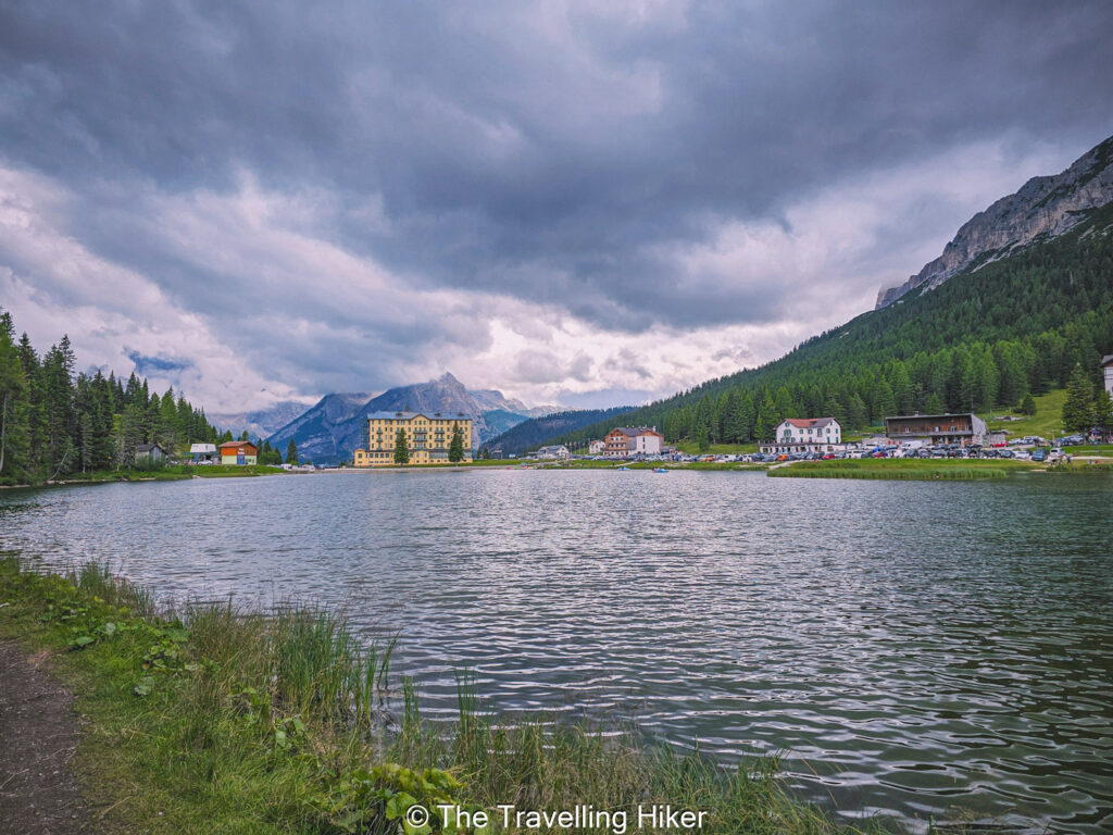
4. LAGO DI MISURINA
DISTANCE: 2,7 km
ALTITUDE GAIN: 93 m
LEVEL: Easy
ROUTE TYPE: Circular
PARKING: Park your car in the big parking lot next to the lake. This parking lot has a parkimeter.
TRAILHEAD/END: The trail begins wherever you manage to park your car. The trail borders all around the lake.
BEST TIME TO DO THE HIKE: This hike can be done all year round. Depending on the season, you will be able to enjoy a very different panorama of the lake.
ESTIMATED TIME NEEDED: 1 hour (with plenty of stops to take photos and enjoy the views).
The Lago di Misurina trail is a calm and easy walk that offers beautiful scenery without any hard climbs. The lake sits in a wide valley surrounded by soft hills and tall peaks. It is a great place to enjoy a slow morning or a relaxed afternoon, and it suits all ages and skill levels.
The path around the lake is flat and very well maintained, so you can follow it with little effort. As you walk, you pass small beaches, quiet forest sections, and open viewpoints that show the mountains from different angles. The trail is really peaceful, and you can stop anywhere to sit, take photos, or simply relax.
Lago di Misurina is also a nice spot if you want to combine a gentle walk with a meal or coffee. There are several cafes and small restaurants near the lakeshore where you can rest and enjoy the view.
If you want a simple and beautiful stop in the Dolomites, the Lago di Misurina trail gives you a perfect break with very little effort.
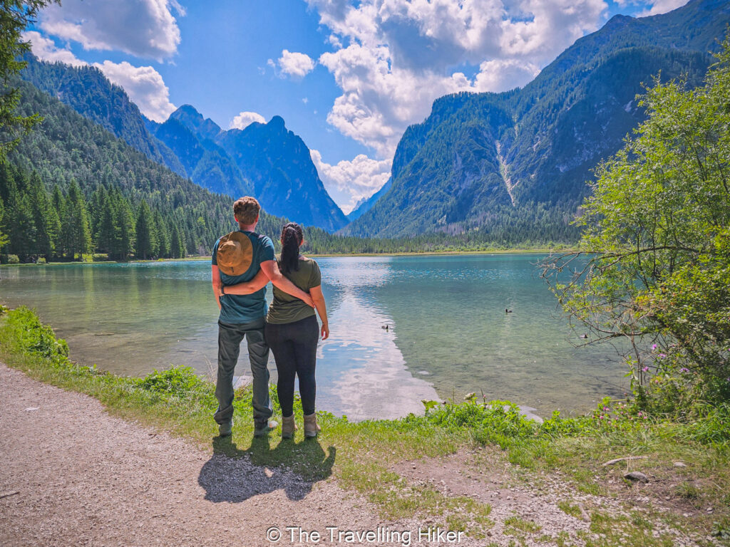
5. LAGO DI DOBBIACO
DISTANCE: 2,7 km
ALTITUDE GAIN: 87 m
LEVEL: Easy
ROUTE TYPE: Circular
PARKING: Park your car in the big parking lot next to the lake. This parking lot has a parkimeter.
TRAILHEAD/END: The trail begins a few meters down the road next to the parking lot.
BEST TIME TO DO THE HIKE: This hike can be done all year round. Depending on the season, you will be able to enjoy a very different panorama of the lake.
ESTIMATED TIME NEEDED: 1 hour (with plenty of stops to take photos, enjoy a snack and admire the views).
The Lago di Dobbiaco trail is a gentle and peaceful walk that lets you enjoy a calmer side of the Dolomites. The lake sits between tall forests and steep peaks, and the water has a deep green color that changes with the light. The trail around the lake is short an easy, which makes it perfect for families or anyone looking for an easy walk in nature.
The trail is very easy to follow. As you walk around the lake, you pass small wooden bridges, shaded forest areas, and open spots that give breathtaking views of the mountains. It is a very relaxing place compared to other more popular lakes in the region.
One of the best things of this trail is that it has plenty of benches where you can sit and admire the views. We visited this lake during a warm summer day and it was the perfect spot to have a picnic lunch, and even take a little “siesta”.
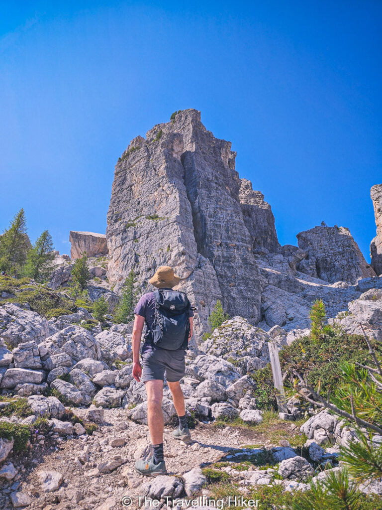
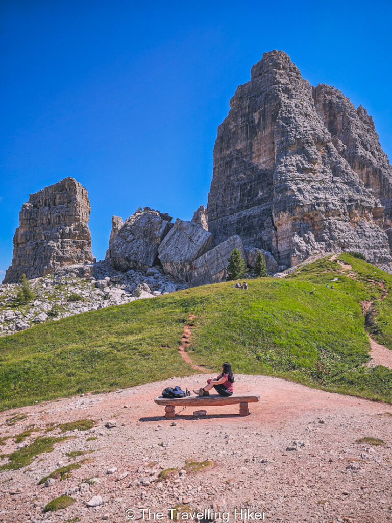
6. CINQUE TORRI HIKE
DISTANCE: 2 km
ALTITUDE GAIN: 118 m
LEVEL: Easy
ROUTE TYPE: Circular
PARKING: Park your car in the Baita Bai de Dones Parking Lot. The parking tends to fill up quite fast.
TRAILHEAD/END: The trail begins at Rifugio Scoiattoli. You will have to take a chair lift to reach it.
BEST TIME TO DO THE HIKE: Between June to September. During the winter months, the trails are covered in snow and used for skiing.
ESTIMATED TIME NEEDED: 2 to 3 hours (with plenty of stops to take photos, enjoy a snack and admire the views).
The Cinque Torri is a fun and scenic trail that brings you close to some of the most unique rock formations in the Dolomites. The five towers rise straight from the ground and create a striking sight that you can see from many angles along the path. The area feels open and bright, and the views of the surrounding mountains add even more charm to the hike.
The hike starts near Rifugio Scoiattoli which can be reached by the nearby chairlift. The trails around Cinque Torri are well marked and easy to follow, and you can choose short loops or longer routes depending on how much time you want to spend. You will walk through grassy slopes, rocky sections, and old military trenches from World War I, which give the area a bit of extra history and interest.
One of the things I liked the most about this hike is that you get to walk right below the towers. Their size and shape look impressive from up close, and it is common to see climbers from trail. This hikes offers the perfect mix between nature and history.
READ MORE: Hiking around Cinque Torri
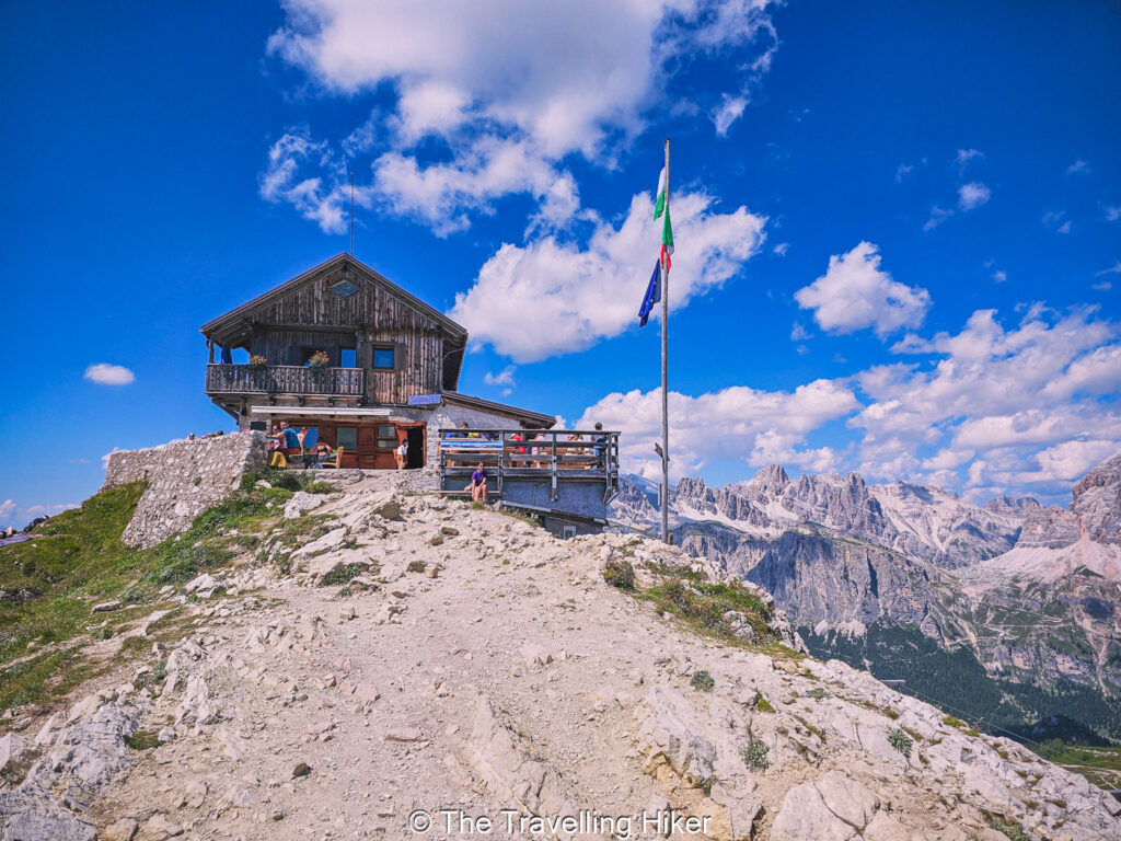
7. RIFUGIO AVERAU AND RIFUGIO NUVOLAU HIKE
DISTANCE: 3,7 km
ALTITUDE GAIN: 330 m
LEVEL: Moderate
ROUTE TYPE: Out & Back
PARKING: Park your car in the Baita Bai de Dones Parking Lot. The parking tends to fill up quite fast.
TRAILHEAD/END: The trail begins at Rifugio Scoiattoli. You will have to take a chair lift to reach it.
BEST TIME TO DO THE HIKE: Between June to September. During the winter months, the trails are covered in snow and used for skiing.
ESTIMATED TIME NEEDED: 2 to 3 hours (with plenty of stops to take photos, enjoy a snack and admire the views).
The hike to Rifugio Averau and Rifugio Nuvolau is one fo the most rewarding routes in the Dolomites. The trails lead you through open alpine scenery with wide views on the different rock formations. The area sits high in the mountains, so you enjoy great “vistas” almost the entire way.
The trail starts from the Rifugio Scoaittoli so many hikers combine it with a visit to the Cinque Torri. The path to Rifugio Averau climbs gently at first, then rises more steeply as you get closer to the hut. Rifugio Averau makes for a great stop to enjoy a warm meal on the terrace with the mountains all around you.
From Rifugio Averau, you can continue to Rifguio Nuvolau. This final stretch is short but a bit steeper, and it brings you to one of the highest viewpoints in the region. Rifugio Nuvolau sits right on the summit and offers a full 360 degree view. On clear days you can see far across the Dolomites, and the rugged peaks look even more dramatic from this height.
READ MORE: Rifugio Averau and Rifugio Nuvolau Hike
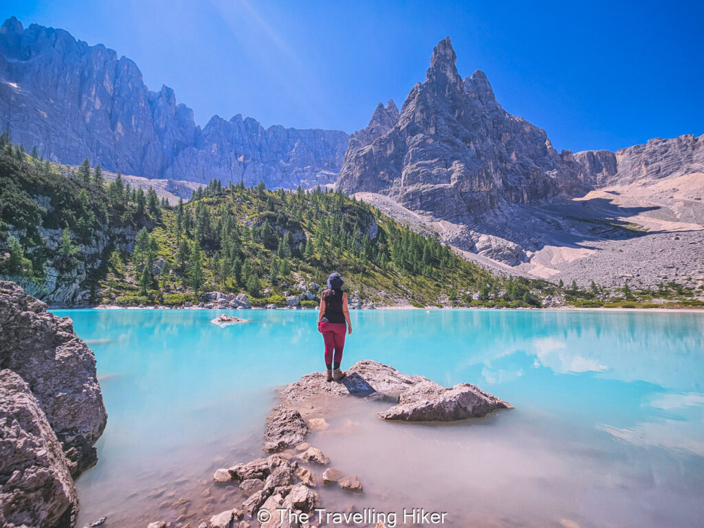
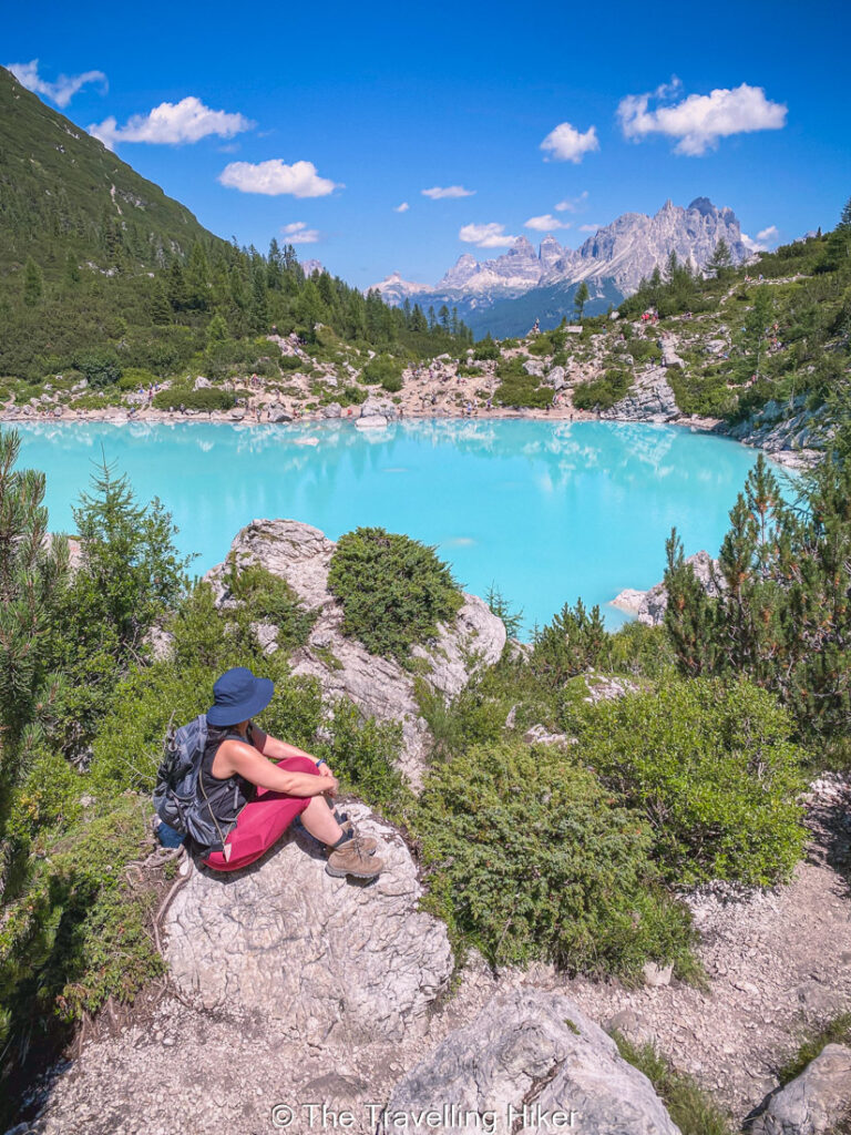
8. LAGO DI SORAPIS
DISTANCE: 12,1 km
ALTITUDE GAIN: 598 m
LEVEL: Difficult
ROUTE TYPE: Out & Back
PARKING: Park your car in the small parking lot next to the trailhead. The parking tends to fill up quite fast.
TRAILHEAD/END: The trail begins at the Passo Tre Croci near Baita Son Zuogo hut..
BEST TIME TO DO THE HIKE: Between June to September to ensure the best weather conditions. During the late autumn months, the lake is almost dry.
ESTIMATED TIME NEEDED: 4 to 5 hours (with plenty of stops to take photos, enjoy a snack and admire the views).
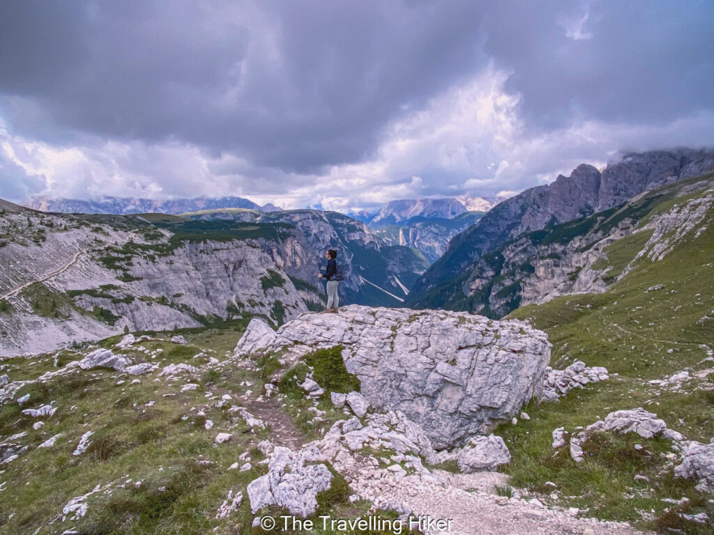
The hike to Lago di Sorapis is another super popular trail in the Dolomites. The bright blue water of the lake makes the effort needed to reach the lake completely worth it. The color looks almost unreal, especially on sunny days, and the sharp peaks around the lake create a striking contrast.
The hike usually begins at Passo Tre Croci (unless you can’t find a parking spot and have to start your hike further down the valley). The trail starts gently through the forest, then becomes narrower as you move along the side of the mountain. Some sections feel exposed, but there are cables to help you stay steady. Take your time here and enjoy the views of teh valley below. The route stays interesting and varied, with a mix of woodland paths, rocky stretches, and opev viewpoints.
When you reach the lake, you will see why hikers love this spot. The water has a soft turquoise color that changes with the light, and the tall walls of Mount Sorapis rise straight above it. It is a great place to rest, take photos, and enjoy a picnic lunch. If you walk around the lake, you can find a few peaceful corners that feel far from the busy trail.
READ MORE: The beautiful Lago di Sorapis hike
9. LAGO DI LIMIDES
DISTANCE: 2,4 km
ALTITUDE GAIN: 135 m
LEVEL: Easy
ROUTE TYPE: Out & Back
PARKING: Park your car in the small parking lot in front of Strobel hut near the Passo Falzarego.
TRAILHEAD/END: The trail begins at the Passo Falzarergo.
BEST TIME TO DO THE HIKE: Between June to September to ensure the best weather conditions. During the late autumn months, the lake is almost dry.
ESTIMATED TIME NEEDED: 1 hour (with plenty of stops to take photos, enjoy a snack and admire the views).
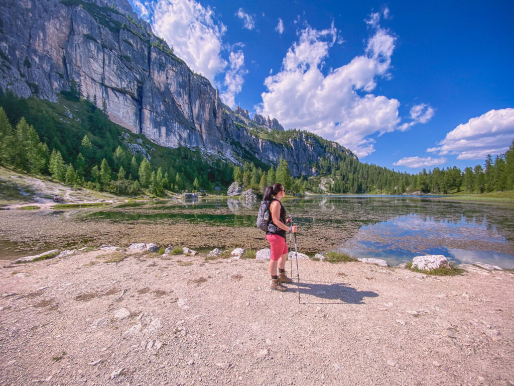
The hike to Lago de Limides is a short and gentle trail that offers big rewards with very little effort. The lake sits on a small plateau near Passo Falzarego, and the views open up almost as soon as you begin to walk.
The trail start from the parking area at the mountain pass and climbs slowly along a wide path. The walk feels easy and pleasant, with soft forest sections and open stretches that give you clear views of the surrounding peaks. You reach the lake in a short time, and calm water often reflects the mountains in a perfect mirror.
Once you arrive at the lake, you can sit by the shore, take photos, or walk around to find your favorite angle. The peaks of the Lagazuoi and the surrounding ridges rise high above the water, and the mix of rock, forest, and open sky creates a peaceful setting.

10. LAGAZUOI TUNNELS
DISTANCE: 3,5 km
ALTITUDE GAIN: 2 m
LEVEL: Moderate
ROUTE TYPE: Point to point
PARKING: Park your car in the parking lot next to the Falzarego – Lagazuoi gondola.
TRAILHEAD/END: The trail begins next to Rifugio Lagazuoi. You will have to take a gondola to reach it.
BEST TIME TO DO THE HIKE: Between June to September to ensure the best weather conditions and clear trails free of ice and snow.
ESTIMATED TIME NEEDED: 2 hour (with plenty of stops to take photos, enjoy a snack and admire the views).
The hike between Rifugio Lagazuoi and the Falzarego Pass is a beautiful route that brings you into the heart of the high Dolomites. The views are wide and open from the start, and the mix of rocky peaks, green slpes, and old mountain paths gives the trail a special charm.
To do this hike, you will have to take the cable car to Rifugio Lagazuoi, which makes the route easiere and allows you to enjoy the scenery without a long climb. If you want to save some money, you can hike up the mountain but then it is more demanding.
From the rifugio, you begin on a clear paths that leads down the mountainside. The trail is steady and manageable for most hikers with a bit of experience, with a few rocky parts that ask for careful steps. As you descend, you will see valleys, tall cliffs, ans winding trails in the distance. The route also passes old military tunnels and trenches, which add a bit of history to the experience. Make sure to bring a good head lamp with you, as some of the tunnels are pitch black dark. You can stop at several viewpoints along the way to take photos or simply enjoy the quiet air.
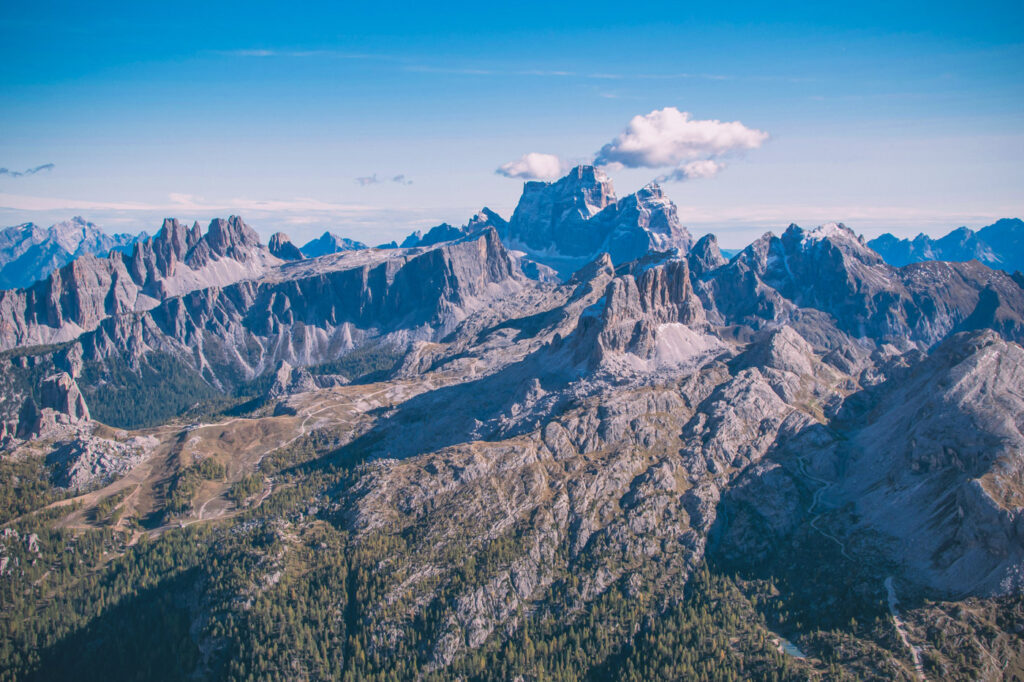
Photo by Matt Foster on Unsplash
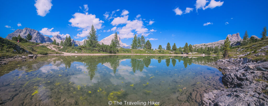
11. CRODA DA LAGO
DISTANCE: 12,6 km
ALTITUDE GAIN: 908 m
LEVEL: Difficult
ROUTE TYPE: Circular
PARKING: Park your car in the parking lot next to Pian del Pantan bus station.
TRAILHEAD/END: The trail begins near Ponte de Ru Curto on the road to Passo Giau.
BEST TIME TO DO THE HIKE: Between June to September to ensure the best weather conditions and clear trails free of ice and snow.
ESTIMATED TIME NEEDED: 5 to 6 hours (with plenty of stops to take photos, enjoy a snack and admire the views).
The Croda da Lago hike is a beautiful and lesser known trail that takes you through forests, open meadows, and rocky mountain scenery. This trail was one of my favorite hikes in the Dolomites because it was peaceful and varied from start to finish. The highlights of the hike are the calm and clear Lago Federa as well as the peaceful alpine meadows after the Forcella de Formin.
The hike starts near Ponte de Ru Curto on the road to Passo Giau. The path begins with a steady climb through a quiet forest. Soon enough, you leave the forest behind and face a steep rocky climb until Forcella de Formin. This is the hardest part of the trail but your efforts will be rewarded once you reach the beautiful alpine meadows, that surround the Croda da Lago group.
From there, the trail is a gentle descend until Lago Federa , which is the perfect place to rest, take photos, and enjoy a snack by the water. To finish your trail, you will descend back through the forest paths until you arrive back at the beginning of the hike.
READ MORE: Croda da Lago Hike
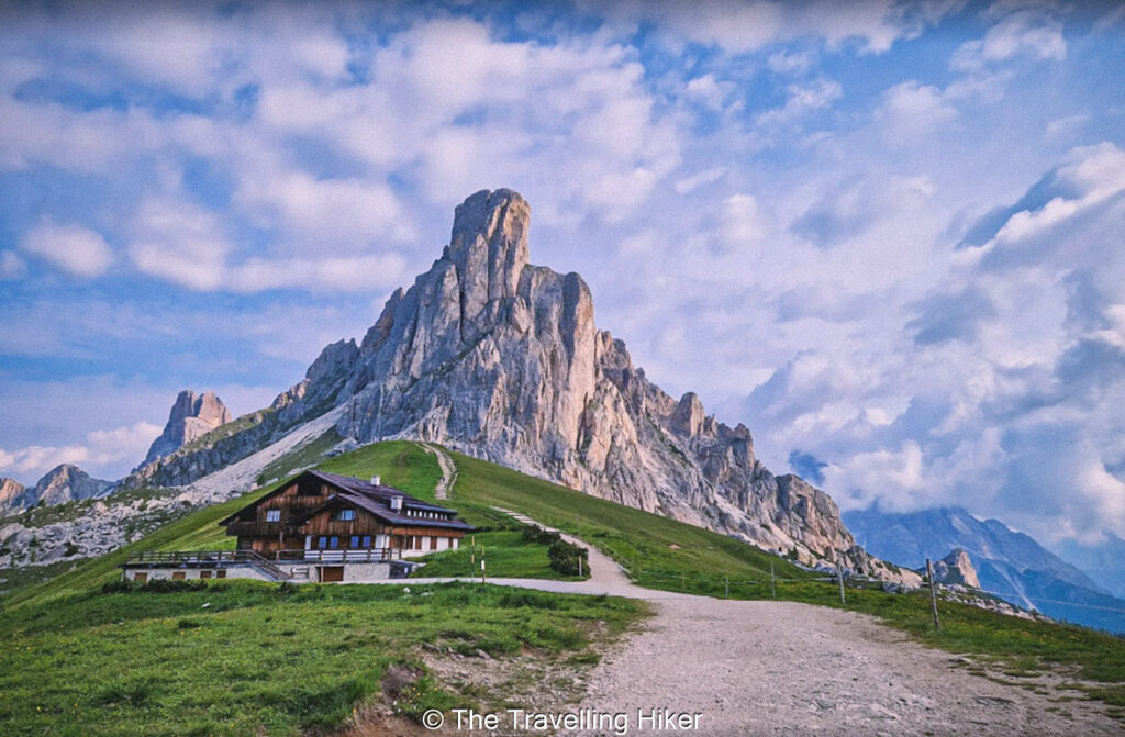
12. TORRE ANNA VIA PASSO GIAU
DISTANCE: 2,4 km
ALTITUDE GAIN: 121 m
LEVEL: Easy to Moderate
ROUTE TYPE: Out & Back
PARKING: Park your car in the Passo Giau Parking Lot. This parking lot tends to fill up fast, so get there early.
TRAILHEAD/END: The trail begins next to the Passo Giau parking lot.
BEST TIME TO DO THE HIKE: Between June to September to ensure the best weather conditions and that the Passo Giau road is open.
ESTIMATED TIME NEEDED: 1,5 hours (with plenty of stops to take photos, enjoy a snack and admire the views).
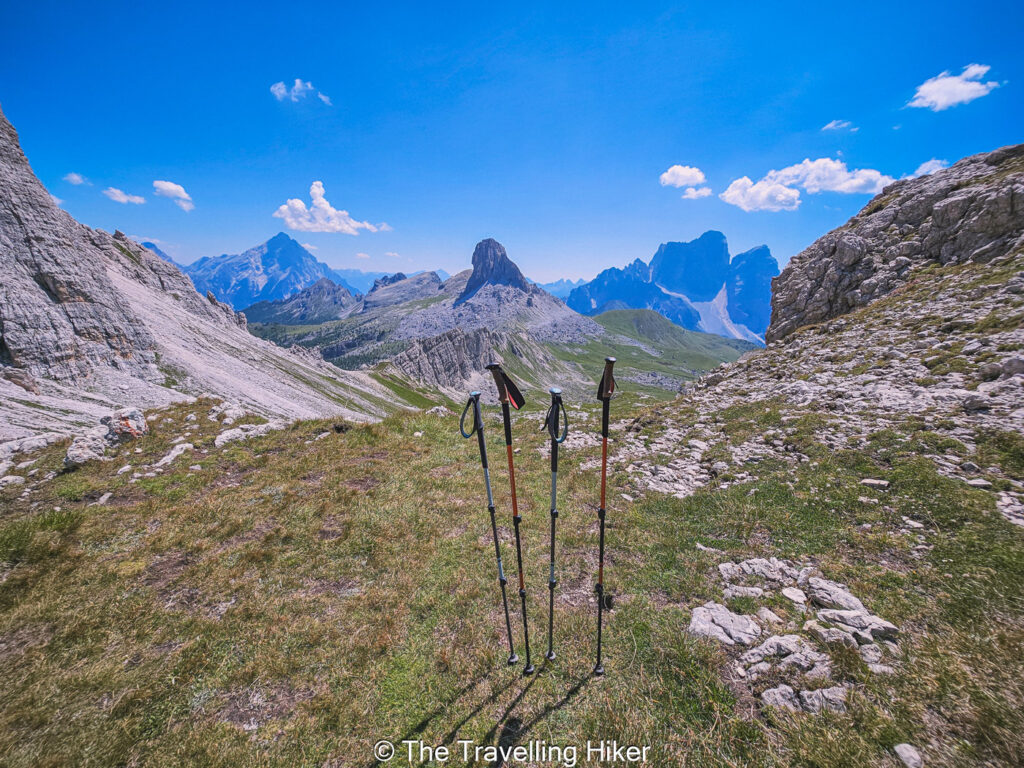
The hike from Passo Giau to Torre Anna is a beautifu and fairly easy trail that gives you wide views and a real sense of open space. Passo Giau is already high in the mountains, so you start the hike with a full panorama of peaks all around you. The pace feels peaceful from the very first steps, and the soft grassy slopes make the early part of the hike very enjoyable.
As you move away from the pass, the trail climbs gently towards the rocky towers above. The landscape changes slowly from rolling meadows to more rugged ground, and the views become more dramatic but don’t worry, the trail stays clear and easy to follow.
Torre Anna appears as a tall and striking rock tower that rises above the ridge. When you get closer, the size and shape of the formation feel even more impressive. This is a great place to rest and take photos before you head back to the parking lot.
13. col raiser - SECEDA - forcella pana - rifugio firenze
DISTANCE: 9,7 km
ALTITUDE GAIN: 553 m
LEVEL: Moderate to Difficult
ROUTE TYPE: Loop
PARKING: Park your car in the Col Raiser Cable Car Parking Lot.
TRAILHEAD/END: The trail begins at the Col Raiser Cable Car top station.
BEST TIME TO DO THE HIKE: Between June to September to ensure the best weather conditions and that the trails are free of snow.
ESTIMATED TIME NEEDED: 5 to 6 hours (with plenty of stops to take photos, enjoy a snack and admire the views).
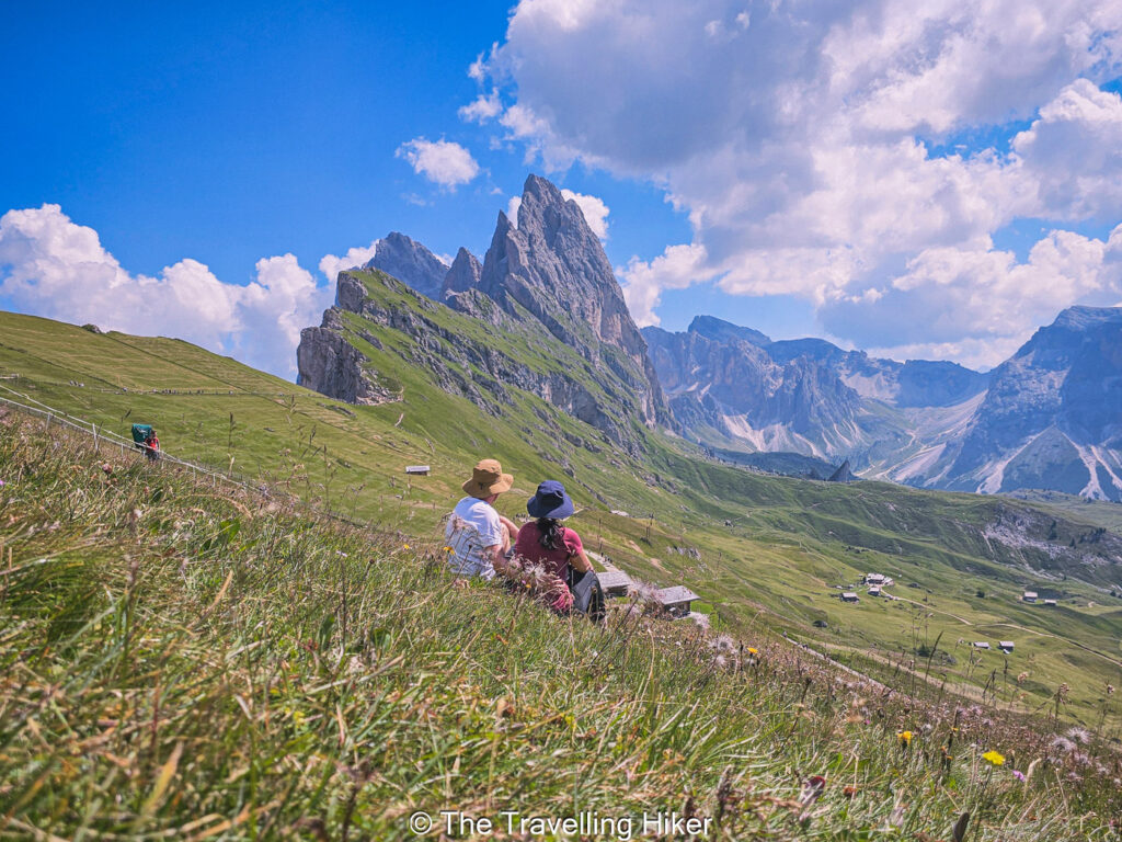
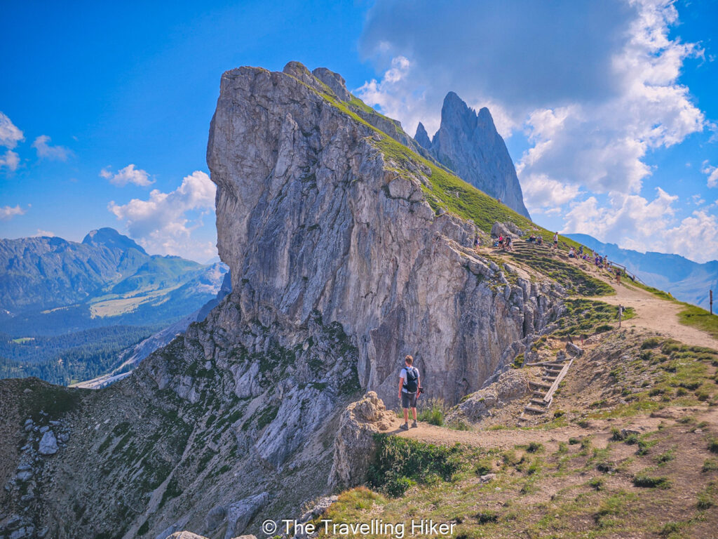
The hike between Col Raiser, Seceda, Forcella Pana, and Rifugio Firenze is one of the most impressive routes you can do in the Dolomites. It gives you a mix of soft meadows, tall cliffs, and quiet alpine valleys. This trail is easy to follow while still offering some of the best views in the region.
To start you hike, take the Col Raiser cable car to avoid quite a bit of elevation gain. From the top station, follow the gentle meadow paths towards Seceda. As you get closer to the famous Seceda ridgeline, the trail gets steep but the impressive view of the jagged peaks will make you keep going. It easy to see why this is one of the most photographed spots in the Dolomites. Take your time and really enjoy this beautiful place.
From Seceda, the trail heads down toward Forcella Pana. The path is easy, with a mix of grassy slopes and small rocky sections. This part of the hike is less crowded, and you will be able to enjoy the cowbells in the distance. Keep descending and following the trail that leads to Rifugio Firenze. The hut sits in a beautiful open meadow with great view of the surrounding peaks. It is the perfect place to relax and cool down before you finish your hike.
READ MORE: Seceda via Col Raiser – Complete Guide
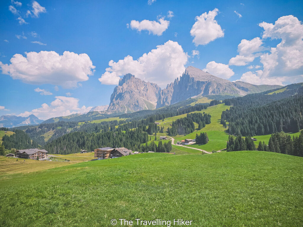
14. ALPE DI SIUSI
DISTANCE: 9,7 km
ALTITUDE GAIN: 280 m
LEVEL: Moderate
ROUTE TYPE: End to End
PARKING: Park your car in the Alpe di Siusi Cable Car Parking Lot in Siusi.
TRAILHEAD/END: The trail begins at Compatsch. You can take the Alpe di Siusi Cable Car to reach it.
BEST TIME TO DO THE HIKE: Between June to September to ensure the best weather conditions and that the trails are free of snow.
ESTIMATED TIME NEEDED: 3 to 4 hours (with plenty of stops to take photos, enjoy a snack and admire the views).
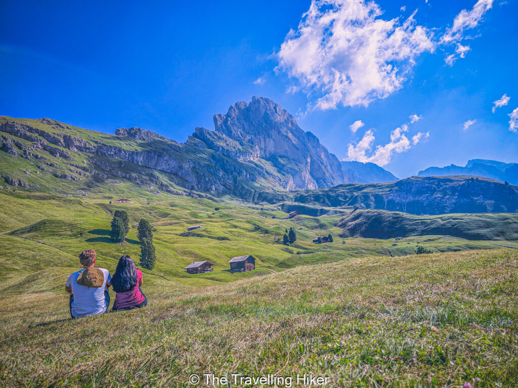
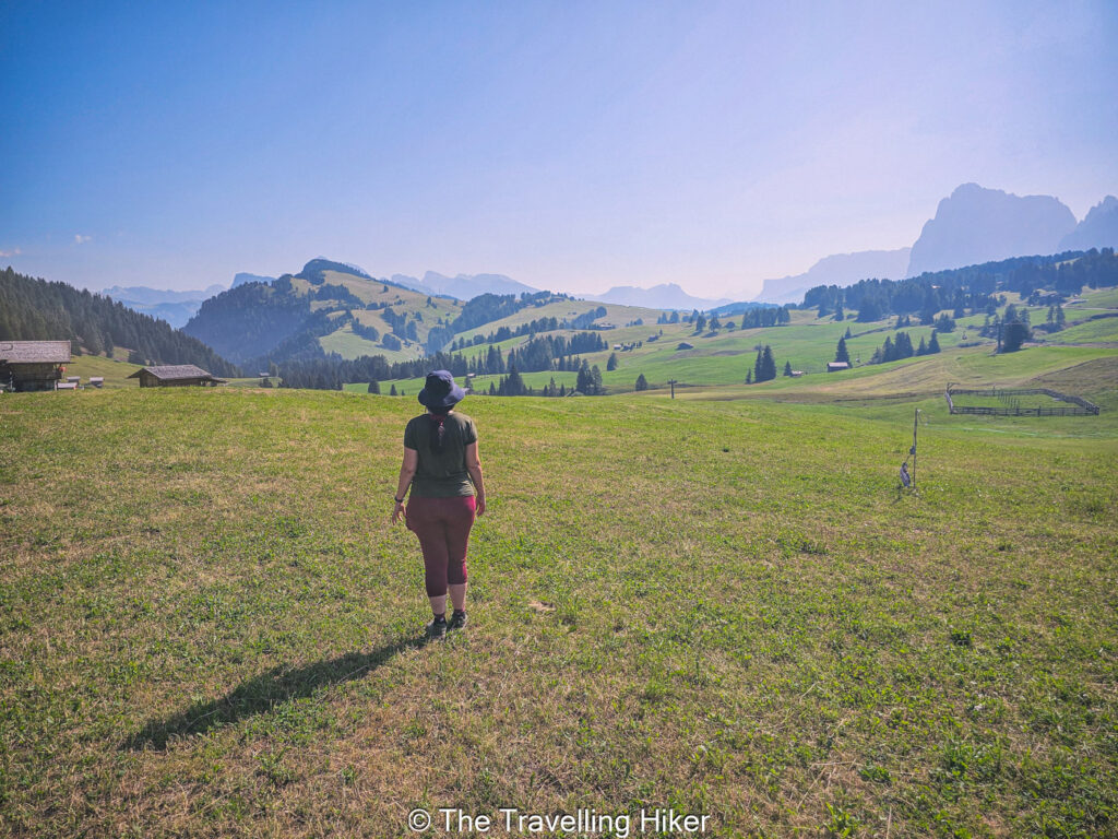
Alpe di Siusi, or Seiser Alm, is a beautiful alpine meadow in the Dolomites. This wide mountain plateau is the largest of its kind in Europe, and you will fall in love with it as soon as you set foot on it. Gentle rolling hills, fres green meadows, and wide paths that make it easy to explore without much effort. The Dolomites peaks rise sharply around the plateau, so you enjoy big views with simple walks.
There are plenty of hiking trails and paths in this area and most of them start at Compatsch. You can choose short loops across the meadows or longer routes that lead you toward the base of the Sciliar and Sassolungo peaks. You can basically decide where to go and how much you want to hike.
Alpe di Siusi is also a great place to combine walking with relaxing breaks. You will find many mountain huts that serve warm meals, homemade cakes, and local drinks. Sitting on a sunny terrace with views of the peaks feels like a perfect reward during or after a gentle hike.
We did an improvised trail from Compatsch to Mount Piz, Sanon Hut and then Saltria, where we had a delicious and comforting lunch, with the most beautiful views. From Saltria, we took the bus back to Compatsch.
READ MORE: Alpe di Siusi Guide
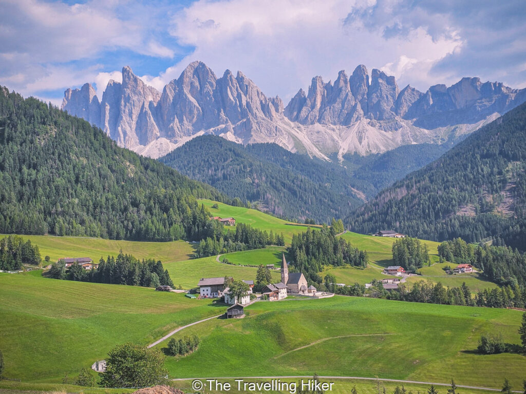
15. SANTA MAGDALENA VIEWPOINT IN VAL DI FUNES
DISTANCE: 5,1 km
ALTITUDE GAIN: 206 m
LEVEL: Moderate
ROUTE TYPE: Out & Back
PARKING: Park your car Santa Magdalena village. The are not that many parking lots, so get there early.
TRAILHEAD/END: The trail begins at Santa Magdalena village.
BEST TIME TO DO THE HIKE: Between June to September to ensure the best weather conditions althought this hike can be done all year round.
ESTIMATED TIME NEEDED: 2 hours (with plenty of stops to take photos, enjoy a snack and admire the views)
Hiking to Santa Magdalena viewpoint in Val di Funes is a simple and very rewarding experience. The trail leads you through soft meadows and quiet farm roads, all with a clear view of the sharp Odle peaks rising above the valley. The view is one of the most famous postcard views in the Dolomites.
The hike starts from the small village of Santa Magdalena. The path climbs gently past wooden barns, open fields, and a few local homes. The walk is easy and pleasant, and the views get better with every step. As you move higher, the peaks become more dramatic, and the green slopes of the valley create a beautiful contrast with the rocks walls above.
When you reach the main viewpoint, the views are unforgettable. You stand above the village, with the chuch below and the Odle mountains rising sharply behind it. Just relax and spend as much time as you want here admiring the breathtaking view in front of you.
READ MORE: Santa Magdalena Viewpoint in Val di Funes
16. ADOLF MUNKEL WEG
DISTANCE: 14,8 km
ALTITUDE GAIN: 744 m
LEVEL: Moderate to Hard
ROUTE TYPE: Loop
PARKING: Park your in the parking lot next to Rifugio Zannes
TRAILHEAD/END: The trail begins at Rifugio Zannes or Zanser Hut..
BEST TIME TO DO THE HIKE: Between June to September to ensure the best weather conditions and that the trails are free of snow
ESTIMATED TIME NEEDED: 6 to 7 hours (with plenty of stops to take photos, enjoy a snack and admire the views).
Hiking the Adolf Munkel Weg is one of the best ways to experience the dramatic north face of the Odle mountains. The trail runs right below the sharp peaks, so walk close to the rocky walls while still walking on an easy and well marked path. The scenery is a mix of green meadows, soft forest sections, and wide open views that you invite you to slow down and enjoy every moment.
The hike begins at the Zanser Alm parking area in Val di Funes. The trail climbs gently through the forest before opening into bright alpine pastures. As you continue, the Odle peaks rise straight above you, creating a fascinating contrast with the smooth landscape below. If you are up to a bit of an extra challenge, you can add a small detour to Brogles Hut to get to enjoy the peaks from a different angle.
Along the trail, you will pass several mountain huts where you can stop for a warm meal or just a drink. These huts always offer great views to the peaks. The combination of great food and great views is one of the highlights of this trail.
READ MORE: Adolf Munkel Trail
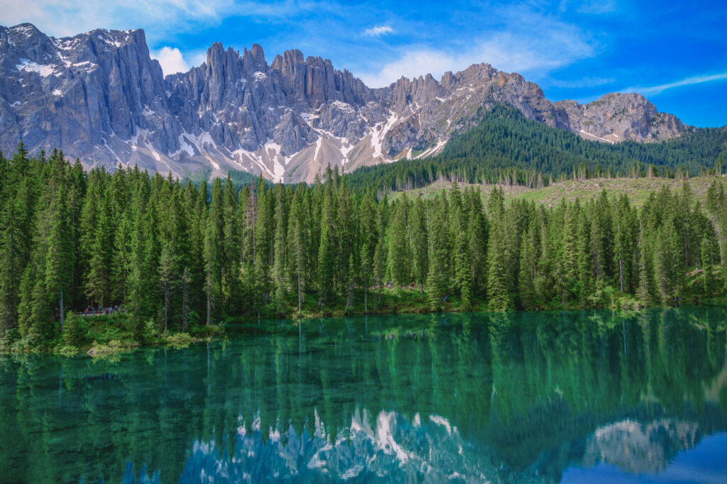
17. LAGO DI CAREZZA
DISTANCE: 1,3 km
ALTITUDE GAIN: 35 m
LEVEL: Easy
ROUTE TYPE: Loop
PARKING: Park your in one of the parking lots next to the lake.
TRAILHEAD/END: The trail begins directly from the parking lot.
BEST TIME TO DO THE HIKE: Between June to September to ensure the best weather conditions and that the road to access it is open.
ESTIMATED TIME NEEDED: 1 hour (with plenty of stops to take photos, enjoy a snack and admire the views).
The Lago di Carezza trail is one of the easiest and most beautiful walks in the Dolomites. The lake is famous for its bright green and blue water, which reflects the Latemar peaks in a perfect mirror on calm days. The trail around the lake is short, smooth, and well maintained, so it suits visitors of all ages and fitness levels.
The hike begins right from the main parking area and circles the lake while offering clear views of the lakes and mountains on the background from many angles. The best moment to visit this lake is in the early morning when the water is the most still and the reflections of the mountains are very clear.
Along the path, there are several viewpoints with wooden railings where you can stop for photos or just stop to enjoy the calm surroundings.
WHEN IS THE BEST TIME TO GO HIKING IN THE DOLOMITES?
The official hiking season in the Dolomites usually starts somewhere in mid June and lasts until end of September or beginning of October depending on the year. Before and after these dates, it is still possible to visit the Dolomites and enjoy some of the hikes but most of them will be covered in snow.
During July and August, you will have the best chances of getting good weather. Although, you can always get a few raining days in the mountains, even if it is summer. These months are also the busiest so you will definitely not be alone of the trails. In these months, it is definitely recommended to start your hikes early to avoid the crowds and to ensuer you get a parking spot.
If you prefer to enjoy the Dolomites with fewer crowds around you, then you can target to visit the Dolomites during June or September. However, in these months, the temperatures will be colder and the risk of rain is bigger.
HOW MANY DAYS DO YOU NEED TO VISIT THE DOLOMITES?
The answer to this question is easy: As many days as possible! The hiking options are endless and the beauty of this region is just amazing! I spent 10 days here and wish I could have stayed even longer.
However, if you have less days, don’t let this discourage you from visiting the Dolomites. Just choose the hikes and villages that appeal you the most and enjoy your time there!
MAP WITH THE BEST HIKES IN THE DOLOMITES
HOW TO USE THIS MAP: Click the star next to the map title to add this map to your google maps account. To view it on your phone while traveling, open Google Maps, click on the menu button and go to “Your Places”, click on Maps and you’ll see this map in your list.
CONCLUSION
And that’s it for this week’s blog. Exploring any of these 17 hikes will give you a real taste of what makes the Dolomites so special. Each trail offers its own mix of bright peaks, calm lakes, soft meadows, and wide views. Whether you choose an easy lakeside walk or a full day in the high mountains, you will find moments that will stay with you long after the hike ends.
If you have any additional question or you want to share your favorite hikes in the Dolomites, please use the comment section.
DISCLAIMER: Did you know? This blog uses affiliate partnerships. When you click and book or make a purchase through one of my blog posts, I may receive a small commission (at no extra cost to you). Thank you for supporting The Travelling Hiker!
OTHER ARTICLES ABOUT ITALY
PIN THIS GUIDE FOR LATER!

