Adolf Munkel Trail Guide

ADOLF MUNKEL TRAIL GUIDE – A BEAUTIFUL ROUTE IN THE DOLOMITES

The Adolf Munkel Trail is one of the most scenic and accessible hikes in the Dolomites, offering incredible views of the Odle peaks without a demanding climb. This Adolf Munkel Trail guide covers everything you need to plan your hike, including where to start, how to follow the route, and useful tips to make the most of your day. It’s the perfect trail if you’re looing for a rewarding hike with stunning alpine scenery and traditional mountain huts along the way.

Located in Val di Funes, the trail runs at the foot of the dramatic Odle range and can easily be adjusted to different fitness levels. The route is well marked, mostly gentle, and idela for anyone who wants to enjoy a panoramic views without tackling a strenuous ascent. In this guide, you’ll find a step by step description of the hike, practical information, and tips to help you plan a smooth and enjoyable experience.

TABLE OF CONTENTS

OVERVIEW OF THE ADOLF MUNKEL TRAIL

The Adolf Munkel Trail is a scenic panoramic hike located in Val di Funes in the northern part of the Dolomites. The trail runs at the foot of the dramatic Odle mountain range and is known for its relatively gentle terrain combined with spectacular alpine scenery. Instead of climbling steeply to high elevations, the path follows a balcony-like route through forests and alpine meadows, making it accessible while still offering impressive views.

The trail is named after Adolf Munkel, a German alpinist and early supporter of hiking tourism in the region. He helpend promote this route as a way for visitors to experience the beauty of the Odle mountains without requiring climbing skills.

What makes this hike special is the constant perspective of the rugged Odle peaks. Throughout the walk, you’ll enjoy some fo the best views of these iconic mountains, with several open sections where the jagged skyline dominates the landscape. The combination of peaceful woodland, traditional mountain huts, and panoramic viewpoints makes this one of the most rewarding hikes in the area.

PRACTICAL INFORMATION ABOUT THE HIKE

HOW TO GET TO the trailhead?

The Adolf Munkel trailhead is located near Zanser Alm mountain hut in Val di Funes. It is possible to start the trail at other locations but this is the most common starting point and offers direct access to the trail.

Getting to Zanser Alm by car

The easiest way to reach Zanser Alm is by car since it will allow you some flexibility with your hike timings. However, the road that leads to this hut is quite narrow and there are a lot of serpentine turns. Make sure you are comfortable with driving these roads before you head here. 

Rent your car with Auto Europe.

All you have to do is follow the road that drives through Val di Funes and follow the directions to Zanser Alm. There you will find a larg paid parking area at the end of the road.

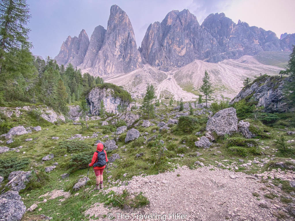
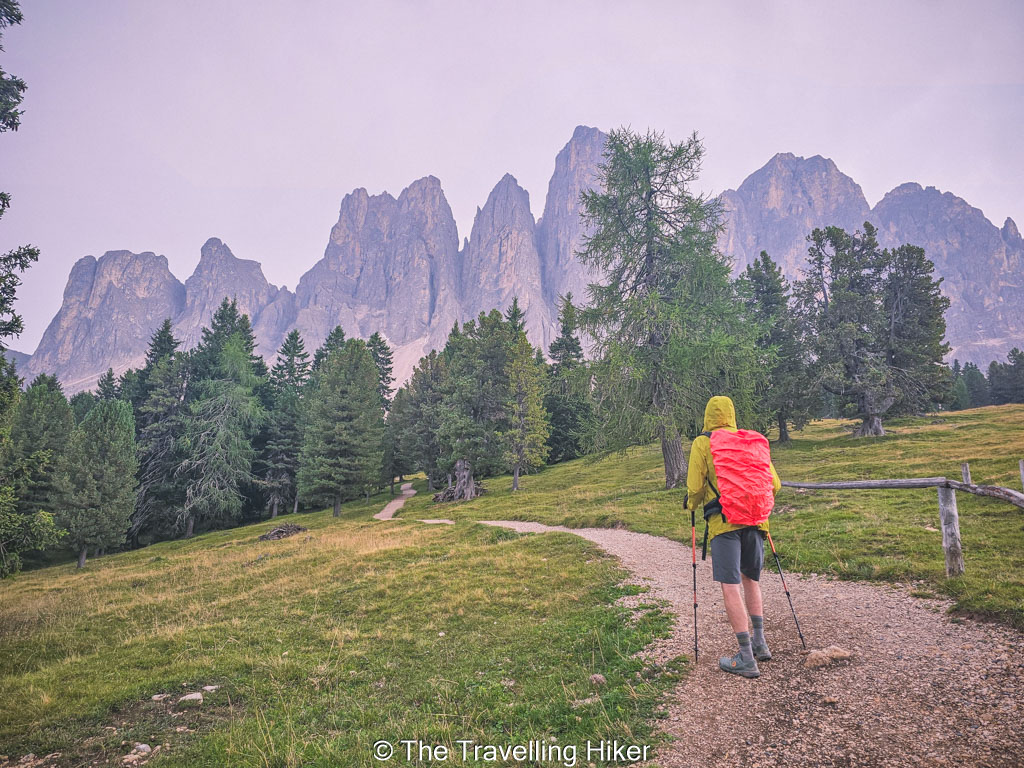
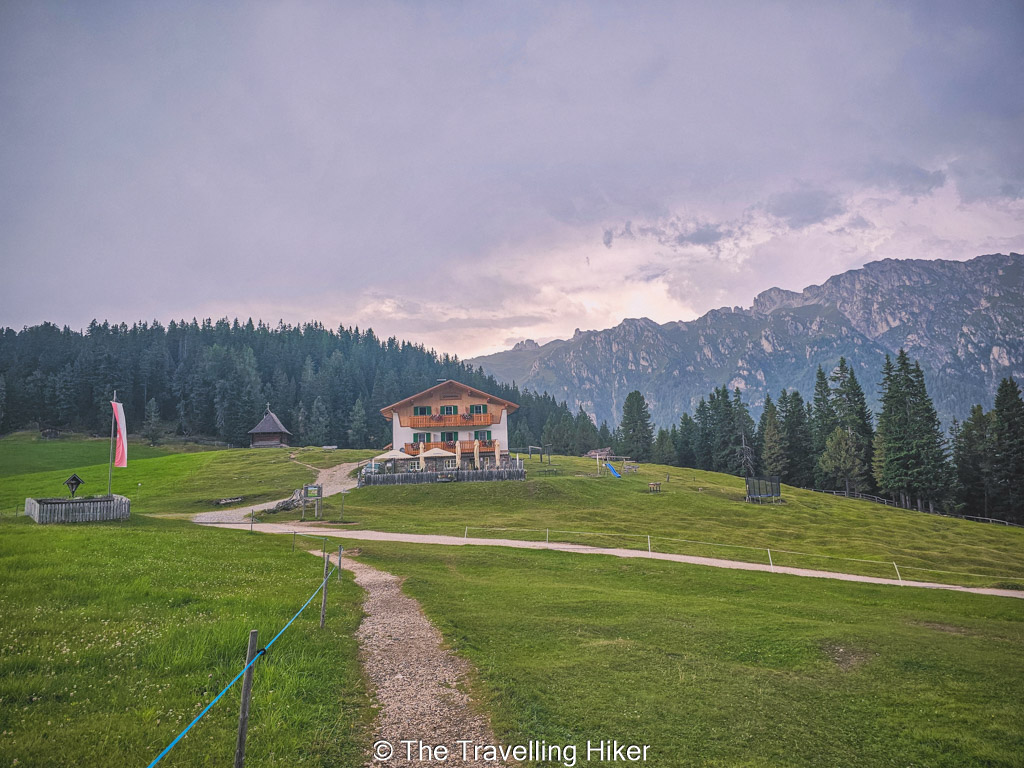
🅿️ Parking: The parking lot at Zanser Alm is quite spacious but it fills up quite quickly during the summer months. We arrived at 9:30 in the morning and got one of the last few parking spots available, so it’s best to start early to avoid any issues.

Getting to Zanser Alm with public transport

If you’re using public transport, buses run from nearby towns such as Brixen and Klausen to Val di Funes, with seasonal services continuing to Zanser Alm. From the final stop, it’s just a short walk to the trailhead. 

Public transport schedules vary depending on the season, so it’s a good idea to check the latest timetables in advance, especially if you’re visiting outside peak summer months.

WHAT EQUIPMENT DO YOU NEED TO HIKE TO HIKE THE ADOLF MUNKEL TRAIL?

The Adolf Munkel Trail is considered a relatively easy hike, but proper equipment will make the experience much more comfortable.

  • Good hiking shoes with decent grip are recommended, as parts of the trail can be rocky or uneven. Even though the elevation gain is moderate, the terrain still requires stable footwear, especially after rain.
  • Lightweight layers are also useful, since weather conditions in the Dolomites can change quickly throughout the day. We began our hike on a beautiful sunny day but we got some rain in the early afternoon.
  • Bring enough water and snacks, particularly if you plan to take your time enjoying the views of the Odle peaks. There are several mountain huts along the route where you can stop for food and drinks, but it’s always wise to be self -sufficient.
  • Sun protection is important as well, since some sectins are fully exposed. 
  • Trekking poles are optional but can help on uneven sections. 

WHEN IS THE BEST TIME TO HIKE THE ADOLF MUNKEL TRAIL?

The best time to do this hike is between late spring and early fall, when the trail is free of snow and mountain huts are open. From June to September, you can usually expect stable conditions and clear views of the Odle peaks. July and August offer the warmest weather, but this is also the busiest period.

Early summer and autumn are particularly beautiful times to visit. In June, apline meadows begin to bloom, while September and early October often bring quieter trails and crisp mountain air. Weather can change quickly in the Dolomites, so it’s always a good idea to check the forecast before heading out.

ADOLF MUNKEL TRAIL

HIKE STATS

Trail Start/End – Zanser Alm Mountain Hut (exact location pinned on the mapa at the end of this blog)

Distance – 15 km

Elevation Gain – 749 m

Level – Moderate to Difficult

Route Type – Circular trail

Estimated Time Needed – 6 to 7 hours (including plenty of time to stop for photos and enjoy the views of the Odle Group)

Best Time To Visit – June to September to ensure the best weather conditions.

Adolf Munkel Trail Guide: Views from Rifugio delle Odle

HIKE MAP

I always use the AllTrails App during my hikes. The app has a GPX map that can help you stay on the right trail during your hikes. For this hike, we followed the Brogles Hut via Adolf Munkel Trail

MY EXPERIENCE HIKING TO BROGLES HUT VIA THE ADOLF MUNKEL TRAIL - STEP BY STEP GUIDE

From Zanser Alm to Dusler Alm

After leaving our car in the parking lot near Zanser Alm (Malga Zannes), we left the mountain hut on our left and started our hike towards Dusler Alm. This first section of the trail followed a forest path with a gentle incline. It was nice way to warm up. We walked through shaded woods while gradually gaining elevation.

Adolf Munkel Trail: From Zanser Alm to Dusler Alm

After about 30 to 45 minutes, the forest began to open up and we reached Dusler Alm. This hut was a great place for a short break with our first views of the Odle peaks in the distance. 

From Dusler Alm to Geisler Alm

After a quick stop at Dusler Alm, we continued along the trail. This section was probably the most challenging part of the hike as it was mostly uphill through a forested area. From time to time there were some openings in between the trees that offered views to the nearby peaks.

Geisler Alm and Malga Casagno

After another 40 to 50 minutes, we reached the famous Geisler Alm or Rifugio delle Odle. This hut is one of the most stop along the route and it is easy to understand why. The hut sits in a beautiful meadow directly facing the Odle peaks. The views were amazing! We couldn’t resist to stop and take a lot of photos.

Adolf Munkel Trail Guide: Rifugio delle Odle
Adolf Munkel Trail Guide: Views from Rifugio delle Odle

A short distance further along the trail, we arrived at Malga Casgno, another hut in a beautiful location where you can enjoy lunch. The views were so impressive we could not resist to find a spot to rest and relax in the middle of the meadow. 

Adolf Munkel Trail Guide

From Malga Casagno to Brogles Hut

After relaxing for a while, it was time to leave the meadow of Malga Casagno behind and head to Brogles Hut. Many people don’t go until Brogles mountain hut because it add a big detour and some extra elavation gain. However, I really recommend doing it, if you have the time and energy. 

The hut sits in a wide alpine basin and offers another beautiful vantage point. To reach it, you’ll have to first descend into a valley and then hike up again until you reach the meadow. 

This was our favorite part of the hike, we were completely alone through the most part of the hike and we had the impressive mountain peaks in front of us while we walked. 

Adolf Munkel Trail Guide

Once we arrived at Rifugio Malga Brogles, it was time to rest, have lunch with an epic view and even take a nap. Nothing beats a nap in a beautiful mountain meadow. 

Adolf Munkel Trail Guide: Brogles Hut

From Brogles Hut to Glatsch Alm

Unfortunately the weather started to turn and we had to leave these beautiful place a bit earlier than we would have wanted. There were some clouds rapidly approaching and we were still half way of our hike.

We first had to retrace our steps and cross the valley that had taken us to Brogles Hut and then, right before getting to Malga Casagno, turn right to continue the trail. We tried to walk as fast as possible but we were caught by the rain. 

Luckily it was not too much rain and we could still enjoy the views whenever there was an opening in the forest. The peaks were just impressive from every viewpoint. 

After some time we arrived at Glatsch Hut (Glatsch Alm), a quieter hut also located in a beautiful meadow. This would have been another great spot to stop and relax if it wasn’t for the rain. 

Adolf Munkel Trail Guide: Glatsch Alm

From Glatsch Alm to Zanser Alm

The final section from Glatsch Alm back to Zanser Alm is mostly downhill. The trail descends gradually through a forest. The path is wide and easy to follow, so we didn’t have to worry about navigation. 

This last stretch was quite short and straightforward and before we knew it, we were back at Zanser Alm. 

OTHER THINGS TO DO NEAR THE ADOLF MUNKEL TRAIL

If you have some extra time, you might consider some other beautiful points in Val di Funes. The area is known for its postcard-perfect scenery, traditional alpine villages, and easy walks with spectacular views. You can easily combine the hike with a few nearby highlights.

One of the most famous spots is the Santa Maddalena Viewpoint. A short walk leads to a panoramic platform overlooking the village of Santa Maddalena with the Odle peaks rising dramatically in the background. It’s one of the most photographed locations in the Dolomites.

Another must-see is the charming Church of St. John in Ranui. This small church sits in a green meadow with the Odle mountains behind it, creating one of the most iconic scenes in the region. 

Adolf Munkel Trail Guide: Church of St. John in Ranui

ADOLF MUNKEL TRAIL FAQ

HOW LONG IS THE ADOLF MUNKEL TRAIL?

The classic loop of the Adolf Munkel trail is roughly 9 to 11 km, depending on the exact variation you follow. You can also make it longer by adding the hike to Brogles Hut, or make it shorter if you are short on time. 

IS THE ADOLF MUNKEL TRAIL DIFFICULT?

The Adolf Munkel Trail is considered a moderate hike. The terrain is mostly gentle, with some elevation gain and well-maintained paths. Some sections can be rocky or uneven, but there are no technical difficulties or exposed areas.

Adolf Munkel Trail Guide

IS THE ADOLF MUNKEL TRAIL FAMILY FRIENDLY?

Yes, it is generally considered a family-friendly hike since it is not too long and has relatively gentle terrain. 

ARE THERE MOUNTAIN HUTS ALONG THE TRAIL?

Yes, there are several huts along the route, where you can stop to enjoy delicious food and drinks while you enjoy the views of the Odle peaks. The most famous mountain hut is Geisler Alm.

WHERE TO STAY IN VAL DI FUNES?

The closest town to Zanser Alm, where the Adolf Munkel Trail begins, is Santa Maddalena. If you are looking for accommodation near the trailhead, then you should book it in Santa Maddalena or any other town in Val di Funes. 

Oberkantiolhof

Oberkantiolhof is a hidden gem in Val di Funes. It offers comfortable rooms and a spa & wellness center where you can relax after a day of hiking and exploring this beautiful region.

Photos from Booking.com

Raschotzhof

Raschotzhof is another good accommodation located in San Pietro, a bit further in Val di Funes. The rooms are comfortable and have great views of the Odle peaks. 

Photos from Booking.com

MAP WITH ALL LOCATIONS

HOW TO USE THIS MAP: Click the star next to the map title to add this map to your google maps account. To view it on your phone while traveling, open Google Maps, click on the menu button and go to “Your Places”, click on Maps and you’ll see this map in your list.

HIKE SUMMARY AND INFOGRAPHIC

FINAL THOUGHTS

The Adolf Munkel Trail is one of the most rewarding hikes in Val di Funes, combining gentle terrain with incredible mountain scenery. With constant views of the Odle peaks, you will remember this hike forever!

Make sure to include this hike on your next Dolomites itinerary!

DISCLAIMER: Did you know? This blog uses affiliate partnerships. When you click and book or make a purchase through one of my blog posts, I may receive a small commission (at no extra cost to you). Thank you for supporting The Travelling Hiker!

OTHER ARTICLES ABOUT THE DOLOMITES
PIN THIS GUIDE FOR LATER!